We’re in Alaska’s “playground” where fishing is king and the sights are spectacular. We’ve had an exciting 2 weeks since our last update and I’ll talk more about the Kenai later, but for now let’s review Fairbanks and our trip moving south.
We arrived in Fairbanks in the middle of summer: high 80’s and excessive smoke from the wild land fires. The biggest is now over 200,000 acres and still burning. Started by lightning it has continually grown and while not threatening any inhabited areas some backwoods cabins have been destroyed but many saved.
They need rain, lower temperatures and reduced winds to get it under control; something that’s not happening soon in interior Alaska.
We were lucky. The winds shifted the day after we arrived in Fairbanks and we had great weather (warm for interior Alaska) and a very busy week. We spent our arrival day cleaning the dust and dirt from our coach and toad and recovering from the rough roads and isolation of the earlier week.
 Welcome to Fairbanks
Fairbanks is the 2nd largest city and has lots to offer. Several large military bases, plenty of shopping and some interesting sights. It’s also right next to the North Pole. Well, geographically it’s not but the Alaskan city of North Pole is a suburb of Fairbanks and yes, Mr. Claus lives there. There are reindeer, Christmas trees and lot’s of elves at the workshop and we made sure our grand children our on the “good little boys and girls list” for this coming December !
 A visit to the North Pole
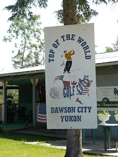
A great Ice Sculpture Museum, a downtown city park and some great restaurants are surrounded by two rivers and lot’s to do. We took the riverboat ride; saw dog sled teams and did a tour of Pioneer Park and a great salmon bake and visited a tribal Pow Wow. Gene & I got in a round of golf at the northern most USGA rated golf course in the US. We visited a fabulous museum run by the University of Alaska and the highlight was a ride up the Dalton Highway to the Arctic Circle.
 Ice Sculpture
 On the 9th Tee....opps, looks who's here...
 A visitor to the Tee Box !
 Laurie & her "scottish" indian ! Dancin' at the Pow Wow !
 A dancer in costume
 Beating the Drum at the Tribal Pow Wow
 Is something looking over our shoulder ?
 Dog sled teams practice.
If you’ve ever watched the History channel’s series “Ice Road Truckers” you’ve seen the Dalton Highway. Over 600 miles of dirt and seal chip highway from Fairbanks to Prudhoe Bay. Miserable conditions in any season. We traveled in a charted van with a driver and 6 others some 150+ miles to the exact latitude of the Arctic Circle, had a picnic lunch and came back. Long day but great scenery and the road follows the Alaska Pipeline route. BTW, it was 75 degrees at the Arctic Circle !
 Our Group at the Arctic Circle.
So, the day we leave Fairbanks and head south the winds shift and the smoke returned. Whew ! A rough ride down the Parks highway toward Denali National Park. We stayed outside the Park in Healy and really had some bad smoke conditions. Our friends had never been there and took the long 12 hour bus tour of the Park.
We’d seen the Mountain in 2004 and with the smoke conditions there were not too many animals to be seen. Mount McKinley was totally obscured. We stayed only 2 nights and moved further south to escape the smoke and haze. Some rain helped but it was still pretty unhealthy.
We made an overnite stop to the Talkeetna area and reprised our 2004 visit there and a stop at an art gallery. The town’s the same but they did blacktop one of the dirt streets since ‘04 and there were lots more local folks. We toured the Mt. McKinley Climbers Cemetery. Since 1932 there have been 249 deaths of climbers on the mountain many of which were never had their bodies recovered. It’s a somewhat chilling experience.
 The river in downtown Talkeetna
 The list of lost climbers in the cemetary.
We moved onto Wasilla and the beautiful Mat-Su Valley. This is suburban Anchorage, home to Sarah Palin and some of the nicest views of mountains and glaciers in Alaska. We were able to get sites at the Palmer Elks Lodge overlooking Finger Lake and nestled in the valley. We took a ride up to Hatcher Pass and toured an old gold mine.
 At the top of Hatcher Pass near Wasilla.
 Hatcher Pass looking back to th Mat-Su Valley
 View from our coach at the Palmer Elks Lodge
We have revised our itinerary somewhat and headed straight south from Wasilla to the Kenai Peninsula skipping Anchorage on the way down. We'll stop on the way back up.
We stopped at the Wildlife Conservation Center near Portage Glacier and got to visit with some of the residents.
 A MuskOx giving his opinion of my actions !
 Can you find the Caribou in this picture ?
 I'm wet, I'm hungry & you look hmmmm !
We did an overnite at the Soldotna Elks Lodge and arrived in Homer, the halibut fishing capital of the world this past Monday.
Unfortunately the rain has arrived with us and it’s been raining the whole time. The views are spectacular, the fishing was great but it’s cold and wet. Most days it never gets out of the low 50’s. We’ll this Monday for Kenai, Seward and Anchorage.
We’ll talk more about the fun and excitement of Homer next time. Till then,
Best Regards,
Gene & Laurie


